
Colzium (World Orienteering Week activity)Sun 17 May
Essential Info
Enter here. Closing date for entries is Thursday May 14, 10am.
Final details are below.
Local event
Local events are competitive but low key and in the 'localised' area, often on a Wednesday evening or a weekend morning. Try O events are local events tailored to anyone new to the sport, with coaches on hand for advice and tips. Open to all ages, abilities and fitness levels, learn to use a map and compass to navigate round short courses.
Training events are non-competitive and used for training and coaching. These are aimed at members of the club, but non-members and newcomers are also welcome. Social events are non-orienteering activities, with the annual highlight being our Awards Evening and ceilidh!
Regional events attract participants from around the local region, National events are high quality competitions that will attract people from far away, and Major events are large competitions such as a British Championships or the JK.
Terrain: Parkland & Forest
Results
Pre-event Information
Location Info
/-4.0362,55.9822,11/500x400?access_token=pk.eyJ1IjoicGF1bGZyb3N0IiwiYSI6ImNtMml0emVpODBtMjAyaXNhNmthNW1oMnEifQ.P6n-xW89MfoytQ4_n7dxPQ)
Near: Kilsyth Lat,Lng: 55.9822,-4.0362 Postcode: G65 0FF What3Words: ///shorts.sprain.deleting
Open an interactive map in: GoogleMap - OpenStreetMap - AppleMaps - BingMap
Directions & Parking
Parking for 15-20 cars available in the park, adjacent to Assembly. Once those spaces are full, there are a couple of other smaller/less convenient parking areas within the park, but your best option is to park in the large layby at the junction with the A803.
Public transport links aren't great, especially on a Sunday. The 344A/B runs from Croy station to Colzium every hour (journey time 20-25 minutes), or if you want a warm-up, it's a bracing 5km jog from Croy station over Croy hill.
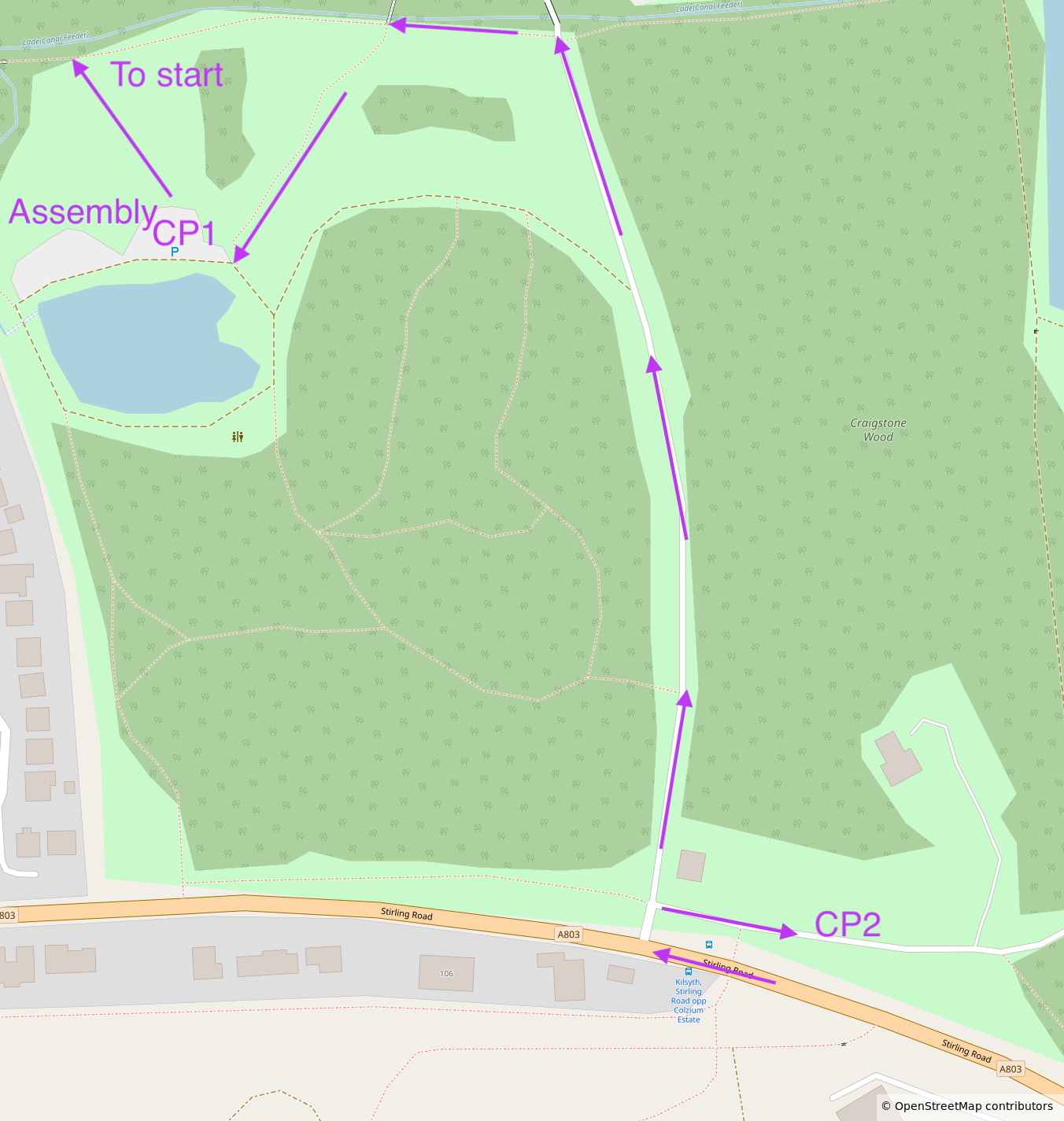
Map & Terrain
All courses 1:7500 A4 ISOM2017-2, brand new (and very nice!) map by Alasdair Pedley, 2026. Very mixed terrain: we have (clockwise from west) scrubby woodland, a lovely but steep wooded river valley, dense and rough forest growing on industrial ruins, vague marshy forest, rough open with a squillion line features, and even a little urban area which we won't use this time. All surrounding a core of grassy parkland and a lovely bit of bumpy open forest strewn with thickets and boulders. If something isn't to your liking, just carry on for a couple of minutes and it'll all be different.
As if that weren't enough, the map also features a model railway, which looks intense on the map (see attached map snippet) but is actually narrow and only used once a month. Treat it as crossable by default; if (exceptionally) we turn up on the day to find tiny trains running on it, we will advise you to avoid it.

And there's a pet cemetery (adjacent to the river valley)! It's unmarked on the map but it spooked one M14 (Sean) when he was testing draft courses and found himself surrounded by tiny gravestones. All courses pass through the cemetery, most likely on clear paths, but maybe brief juniors not to be freaked out by the headstones.
Course Information
| Course | Length | Climb | Controls | ||
| Yellow | 1.6km | 60m | 10 | TD2 | |
| Orange | 1.8km | 75m | 10 | TD3 | |
| Light green | 3.4km | 110m | 15 | TD4 | Map flip |
| Green | 4km | 135m | 17 | TD4/5 | Map flip |
| Blue | 5.4km | 210m | 23 | TD4/5 | Map flip |
Loose control descriptions here
There are lots of controls close together in the nicest parts of the area, with some controls only just over the minimum separation distance. Check your codes!
The Orange course contains a couple of control sites tucked away behind obvious contour features near paths. These legs are near the top end of TD3. I've included them to tie in with Stars Level 3 training on contours planned for the same morning. If any junior is unsure how to approach these legs, please ask for help or consider shadowing.
Some courses may pass close to Finish and Assembly midway through the course.
Entry Details
Enter here. Closing date for entries is Thursday May 14, 10am.
Registration & Start times
Start times 11:30-13:00. Courses close 14:30.
Assembly is adjacent to the small car park next to the pond in the centre of the park. Collect hired dibbers here.
All courses have a remote start, c.450m from Assembly. Please follow a taped route to get to the start.
Finish is in sight of Assembly, but on the other side of the pond. There will be a taped route back to Assembly avoiding the car park as far as possible.
Facilities
There is a small cafe in Colzium House with a couple of toilets, but you might have to buy something to use the toilet, so probably best to plan in advance. Having said that, they do nice lentil soup and you can sit in a lovely walled garden which is sadly marked as out of bounds on our map. They would appreciate our support so go and buy some soup after your run (other options are available).
Safety Notes
- The area is bisected by a deep river valley (N-S) with crags on each side, and a leat (E-W) which has recently been wider/deeper/muddier in reality than you might guess from the map. There are no mandatory / prohibited crossing points for these water features. Yellow and Orange courses have been planned with controls on bridges to guide juniors to cross at safe places, and juniors should have no reason to go in the water at any point. For other courses, you can cross anywhere, but in many cases you would still do well to cross at bridges.
- There is a large marsh close to assembly. On recent visits, the northern part of this marsh has been marshier than mapped (above my knees even where mapped as seasonal marsh). All courses are planned to lead you away from the worst part, and Yellow/Orange stay away entirely.
- The park contains a couple of small roads (15mph speed limit) with only small amounts of traffic, and three small parking areas. All courses cross these roads and car parks at least once. Although the risk is low, given low traffic volumes and low speeds, parents may wish to shadow young juniors.
- The Blue course crosses the A803 twice. The crossing point is mandatory, and a control is very close to the crossing point (visited when crossing in both directions) to reinforce the mandatoriness. There will be a marshal at the crossing point — please obey their instructions and take care.
- The area south of the A803 has areas of litter/fly-tipping. Hopefully the course will keep you away from the worst of it. It also often has a few people riding scooters on the bigger paths.
- The area is popular with dog-walkers and the public in general. Please remember to share space.
- Please check for ticks after your run.
Contacts & Officials
Organiser Rob Truswell (email hidden; JavaScript is required)