
MuiravonsideWed 8 Apr
FVO Wednesday Evening Series
Local series of forest orienteering events running from Easter until the summer holidays.
Four courses offered:
- Yellow - (1.5km to 2km). Relatively simple navigation, mostly on paths. Searching for obvious features like path junctions and stream crossings.
- Orange - (2km to 3km). Slightly tougher navigation, which may take you off paths. Searching for features like boulders and tree stumps.
- Green - (3.5km to 5km). Tough navigation, off path and searching for more obscure features, such as depressions and re-entrants.
- Short Green - (3km to 4km). A shortened version of the Green course - just as tough, but less distance.
Start times: 1730-1900
Entries for all WEEs will be taken through the FVO entry system.
Local event
Local events are competitive but low key and in the 'localised' area, often on a Wednesday evening or a weekend morning. Try O events are local events tailored to anyone new to the sport, with coaches on hand for advice and tips. Open to all ages, abilities and fitness levels, learn to use a map and compass to navigate round short courses.
Training events are non-competitive and used for training and coaching. These are aimed at members of the club, but non-members and newcomers are also welcome. Social events are non-orienteering activities, with the annual highlight being our Awards Evening and ceilidh!
Regional events attract participants from around the local region, National events are high quality competitions that will attract people from far away, and Major events are large competitions such as a British Championships or the JK.
Terrain: Parkland & Woodland
Results
Livelox - if you recorded your run with a GPS watch you can replay it on the map. Just sign up to Livelox (for free) and link it to your Garmin, Suunto, Coros etc. account.
Overview
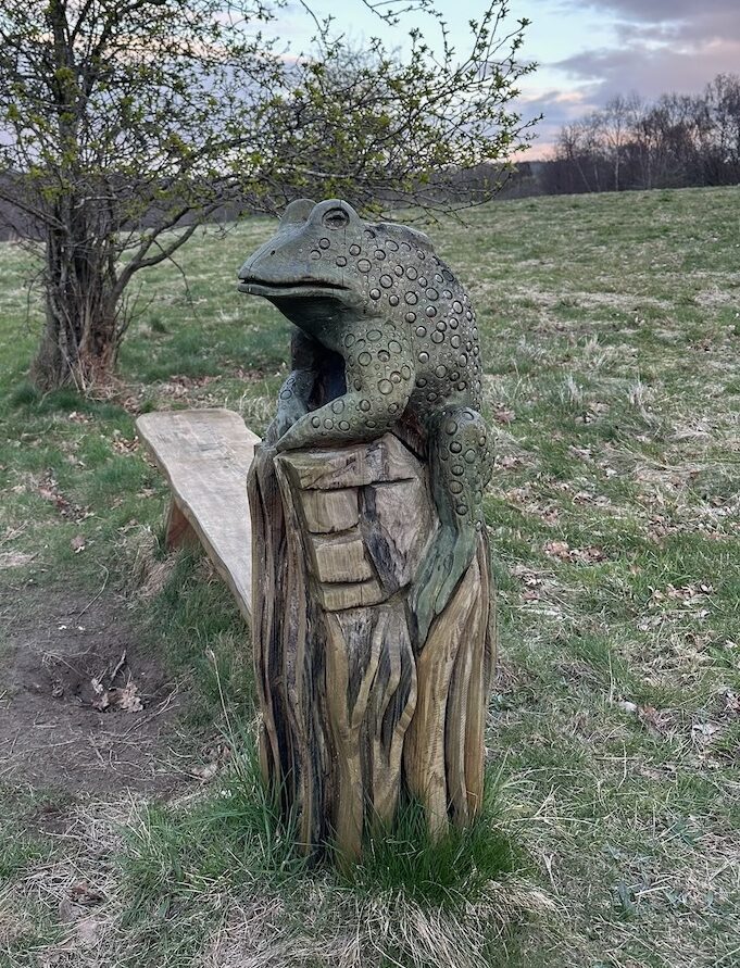
The WEE season opener is at Muiravonside Country Park. Good mix of old and new woodlands, open parkland and some tricky slopes - plus some interesting beasts to have a look at after your run!
Pre-event Information
Location Info
/-3.6615,55.9618,11/500x400?access_token=pk.eyJ1IjoicGF1bGZyb3N0IiwiYSI6ImNtMml0emVpODBtMjAyaXNhNmthNW1oMnEifQ.P6n-xW89MfoytQ4_n7dxPQ)
Near: Linlithgow Lat,Lng: 55.9618,-3.6615 Postcode: EH49 6LN What3Words: ///melt.loses.lavished
Open an interactive map in: GoogleMap - OpenStreetMap - AppleMaps - BingMap
Directions & Parking
Parking is in the main country park car park. You need to take a ticket to get into the woodland car park then go through that and on to the main car park. On your way out you'll need to scan your ticket at the barrier and pay £4 to get out.
It's also possible to take the train to Linlithgow (or Polmont) and then cycle or jog along the Union canal to get there.
Map & Terrain
1:7500, 5m contours. Mapped by Chris Smithard and updated last year by Joe Hudd.
Course Information
Courses are deliberately on the short side, to allow for tired legs after the JK!
- Yellow (TD2) - 1.4km
- Orange (TD3) - 2.1km
- Short Green (TD5) - 3.2km
- Green (TD5) - 5.0km
Courses close at 8pm sharp!
Entry Details
Registration & Start times
Registration, start and finish all adjacent to the car park. Starts from 5.30-7pm.
Facilities
Toilets in the country park will be closed during the event. Usual bag and key drop at start/download.
Safety Notes
There are some steep cliffs above the river but the courses don't go anywhere near these. Finish is slightly remote from start/download - follow the green tapes to get back from the finish.
Contacts & Officials
Paul Hammond (email hidden; JavaScript is required)